Manaslu Circuit Trek: What the Restricted Area Permit Gets You

The first thing you notice above Soti Khola is the change in the plants. Below the trailhead the hillsides hold banana trees and the kind of undergrowth that suggests the lowlands are not far. An hour of walking and the vegetation shifts. The rhododendron starts. The ferns grow taller. The trail narrows and turns inward, following the Budhi Gandaki river through gorges where the water sounds closer than it is.
By the time you reach Jagat, the entry checkpoint, your guide has already handed over the first set of permits. You signed them in Kathmandu. You may not have read them closely. They have three names: the Restricted Area Permit, the Manaslu Conservation Area Permit, and the Annapurna Conservation Area Permit. The first is the one that matters. The other two are conservation fees. At Jagat, a ranger records your name in a ledger and returns the papers without ceremony.
The permit, in that moment, feels like a formality.
It takes another twelve days to understand what it actually got you.
Three permits and what they mean
The restricted area designation on the Manaslu Circuit is not a bureaucratic relic from another era of Nepal trekking. It is actively enforced. The permits are checked at multiple points along the route: Jagat, Deng, Namrung, Lho, Samagaun, and at the Larkya La checkpoint. Your guide carries the folder and manages each interaction. Most trekkers never handle the papers again after Kathmandu.
The cost is approximately USD 100 per person in total across all three permits, with the RAP priced lower in the off-season months. The guide, mandatory rather than optional, adds significantly more. Independent trekking is not permitted on the Manaslu Circuit. You must enter with a licensed guide and as part of a group of at least two people.
That second rule matters more than it seems. Solo trekkers arriving at a checkpoint without a companion are turned away. Some arrange for the guide to count as the second person. Some are paired with another solo trekker at the checkpoint. It is worth settling before you arrive.
What the permit restricts is not only who enters but how many. Total trekker numbers on the Manaslu Circuit remain a fraction of those on the Everest or Annapurna routes. That controlled access is what every trekker actually buys when they pay the permit fee.
What the guide is actually for
The guide requirement on the Manaslu Circuit is often framed as a compliance issue. You need a guide because you need the permit, and the permit requires a guide. That is technically accurate. It is also incomplete.
The Manaslu trail is less marked than the Everest Base Camp route. Above Samagaun, in particular, the path becomes ambiguous. Junctions are not always signposted. The trail crosses river sections where the route shifts seasonally. Trekkers who have walked EBC and expected similar signage have found themselves uncertain above the snowline.
The guide manages the checkpoints, yes. The guide also books the teahouses, which matters because teahouses above certain elevations are small enough that there is no second option if the first is full. And on the Larkya La day, when you leave at 4:30 in the morning in the dark and the trail is not visible from twenty metres, the guide is the person who knows which direction the mountain goes.
The route in zones, not days
Most published guides to the Manaslu Circuit present a day-by-day itinerary. Soti Khola to Machha Khola to Jagat to Deng to Ghap to Namrung to Lho to Samagaun to Samdo to Dharmasala to Bhimthang to Tilje to Dharapani. Fourteen or fifteen days depending on rest days, acclimatisation, and starting point.
The day-by-day is useful for planning. It is less useful for understanding what the trek actually feels like.

The Manaslu Circuit divides more naturally into three zones.
The lower section, from Soti Khola to Deng, follows the Budhi Gandaki river through narrow gorges and bamboo forest. The elevation gain is gradual. The villages are small and the teahouses basic. This is where the rhododendron is densest, where the trail is most overgrown after the monsoon, where suspension bridges are strung between rock walls and the river sound never fully leaves.
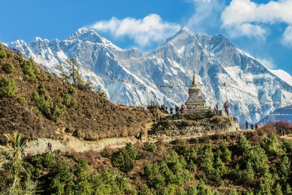
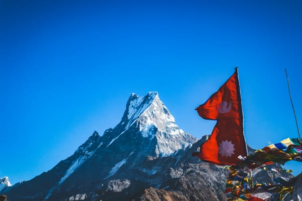
The middle section, from Deng through Namrung, Lho, and into Samagaun at 3,520m, is where the high Himalayan scenery arrives. Manaslu itself, at 8,163m, becomes visible above Lho and stays visible for the rest of the trek. The villages are Tibetan in character: flat-roofed stone houses, mani walls, prayer flags strung across the trail. Acclimatisation days are taken here. Teahouses run slightly larger menus.
Samagaun is the anomaly. In the middle of altitude and austerity, it has a menu that includes pizza. Trekkers who have been eating noodles and lentil soup since the trailhead spend more time here than the itinerary suggests.
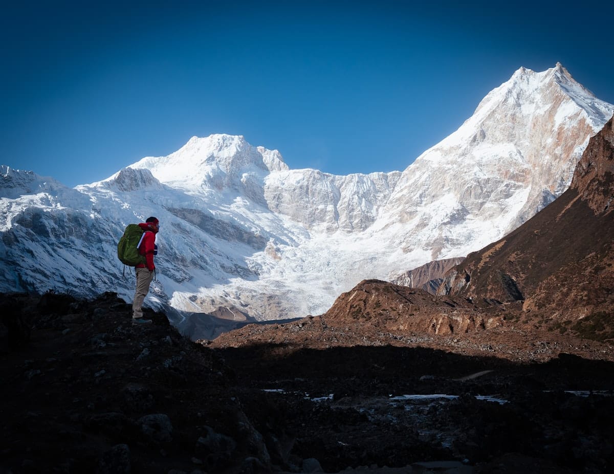
The upper section, from Samdo through Dharmasala and over Larkya La, is the part the trek is remembered for.
Dharmasala the night before the pass
Dharmasala sits at 4,466m and exists for one reason: to give trekkers somewhere to sleep before the Larkya La crossing. There is not much else here. A few rooms cut into the hillside. One small kitchen. No heating.
In November, which falls within the recommended season, the temperature at Dharmasala drops well below zero overnight. One trekker told us the teahouse provided a hot water bottle, the only warmth available. They slept in all their winter trekking gear and were still cold. The menu was limited. There was no second teahouse to try.
What no published guide mentions is the particular quality of the night before the pass. The mountain is outside and you cannot see it in the dark, but you can hear the wind. The alarm is set for 3:30 AM. The pass is at 5,160m. The descent on the far side is steep. These things are not frightening in themselves. But they accumulate in a cold room at altitude while the wind works at the walls.
Larkya La
The alarm goes at 3:30 AM. By 4:30, you are on the trail with a headlamp and whatever layers you own.
The ascent to Larkya La takes three to four hours. In good conditions it is cold and steep and long, but manageable. The summit plateau opens onto a corridor with high peaks on both sides and the Budhi Gandaki valley eventually visible far below. On a clear morning, the view requires no commentary.
The descent is where most injuries occur. The Bhimthang side of the pass is steeper, looser, and significantly more technical than the ascent. Microspikes are not optional if there has been overnight snow or ice, and at this elevation in October or November, there usually has. The trail drops 1,600m to Bhimthang. Knees register their objections around hour two of the descent.
One trekker described walking a section of the pass alone: the head tilting from side to side, trying to hold the peaks in memory before the descent took them away.
The pass is the longest day of the trek by a significant margin. Most trekkers leave Dharmasala and reach Bhimthang in eight to nine hours.
What separates Manaslu from EBC and Annapurna
The comparison to Everest Base Camp is inevitable. Both are multi-week Himalayan treks. Both involve significant altitude. Both require logistics that most trekkers delegate to an agency.
The Manaslu Circuit is longer and harder. Approximately 30% longer in total distance. The hardest single day involves 27km and 1,600m of elevation gain. The acclimatisation schedule gains 6,000m in the first four days, which is a fast rate. The trail is less maintained, the signage less reliable, the teahouses smaller with shorter menus.
The Annapurna comparison is different. The Annapurna Circuit has been progressively shortened by road construction and is now partly driven. The Manaslu Circuit has no equivalent compromise. You walk the full distance. The restricted area designation has prevented the road development that has reshaped the Annapurna route over the past fifteen years.
That is the clearest practical answer to what the permit gets you. On Annapurna you share the trail with jeeps. On Manaslu you do not. On EBC you follow a path so well-worn that losing it requires effort. On Manaslu the guide earns his fee.
Permits, costs, and timing
The three permits are: the Restricted Area Permit (RAP), the Manaslu Conservation Area Permit (MCAP), and the Annapurna Conservation Area Permit (ACAP). Combined cost: approximately USD 100 per person in peak season. For cash logistics on trek, see the Nepal currency exchange guide. The RAP is priced lower in November through February.
Most agencies charge USD 800-1,000 per person for a package covering guide, porter, permits, teahouse accommodation, and meals. Solo travellers should confirm whether the package includes a second trekker or whether pairing with another group is required.
Recommended seasons: October-November for post-monsoon stability and mountain visibility; March-April for pre-monsoon clarity and rhododendron at lower elevations. November now occasionally produces rain at high elevation, a shift from historical patterns. Carry waterproof gear regardless of season.
The Tsum Valley can be added as a side route from Chhokang Paro. It requires a separate restricted area permit, adds four to seven days, and involves a distinct set of villages with its own character. Most trekkers skip it due to time. The Tsum Valley permit must be arranged before leaving Kathmandu.
Frequently asked questions
Do you need a guide for the Manaslu Circuit?
Yes. A licensed guide is mandatory and independent trekking is not permitted. You must also enter with at least one other trekker. Solo permits are not issued.
Is Manaslu harder than Everest Base Camp?
Yes. The circuit is approximately 30% longer, steeper in several sections, and the trail is less maintained. The longest single day (27km, 1,600m of elevation gain) is harder than any single day on the EBC route.
How many days does the Manaslu Circuit take?
The standard circuit takes fourteen to fifteen days. Adding the Tsum Valley extension adds four to seven days.
What permits are required?
Three: the Restricted Area Permit (RAP), the Manaslu Conservation Area Permit (MCAP), and the Annapurna Conservation Area Permit (ACAP). Your guide manages all permit paperwork at each checkpoint along the route.
What is the best time to trek the Manaslu Circuit?
October-November and March-April. Avoid the monsoon months (June-September). November can now produce rain at high elevation, which was historically rare.
Can you combine the Manaslu Circuit with the Tsum Valley?
Yes. The Tsum Valley requires a separate restricted area permit and adds four to seven days. Arrange the permit before leaving Kathmandu.
Back to the permits.
Three permits. One that restricts access, one that funds conservation in the Manaslu region, one that funds conservation in the Annapurna zone, because the circuit exits through that zone. A folder your guide carries and presents at each checkpoint while you walk ahead or stop to drink water.
By Bhimthang, after the pass and the descent and the eight or nine hours of the Larkya La day, the answer to what the permit got you is clearer. It got you the trail without the jeep. It got you the teahouse that had one room left. It got you the pass in the dark at 4:30 in the morning with nobody else on the mountain.
It got you the fourteen days before that, too. The rhododendron above Soti Khola. The mani walls at Namrung. The north face of Manaslu from Lho. The pizza in Samagaun, which you remember more fondly than you expected. The no-heat room in Dharmasala and the hot water bottle and the sound of wind on the mountain the night before the pass.
That is what the restricted area permit gets you. Not a view from a destination. A fourteen-day accumulation of things the permit kept quiet.